Maps tell compelling stories about communities and world we live in. They are a visualization tool to transform bulk of data into information about people and places. We can leverage the power of maps for groundbreaking innovations and causes. People have been using maps for multiple purposes since its inception as in navigation, astronomy, military and many others.
Maps serve for economic revolutions to humane undertakings. As we know, calamities are an inevitable aspect of nature, at times these calamities are so severe that it leaves the human race in despair. Natural disasters like Earthquakes, Tsunamis, Floods, Hurricanes, etc. devastate the habitat and leave the inhabitants pining for help. Non-profit organizations usually lend a helping hand to civil rescue operations in such a scenario.
We are going to see how using the power of maps we can conduct successful evacuation or relief missions. Hector is a Rescue Unit Officer serving as the leader of his volunteer team. Unfortunately there is a catastrophic flood in the city causing loss of lives and resources. Relief must be instantly provided to the victims. Hector was instructed to provide help to the victims with his team.
He uses maps to make the task of distributing resources and conducting rescue operation. Using Radius Search feature of Maplytics first his team locates the Warehouses in order to collect the goods from there to be distributed. He looks for Community Centers and Warehouses within a radius of 20 miles in order to distribute the goods and also pick up the stranded people from Community Centers to safer places. Hector has five Choppers under his supervision.
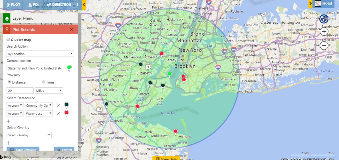
The goods are to be picked up from the Warehouse and dropped to Community Centers at nearest location. Using Proximity Search he can find sight distance from the starting point to Warehouse and Community Centers. Further, Hector decides to do Concentric Proximity Search so that he can allot choppers to certain radius for dedicated task. So he plots three radii in order to determine which areas need maximum attention by viewing the number of Community Centers and thus which need more number of choppers. He plots three radii 10, 15 and 20 miles.
The innermost radius of 10 miles has the maximum number of Community Centers and is at nearest distance from the current location, from where rescue mission is held, and most victims are there. The second radius has Warehouses but no Community Centers so only one chopper is sent there to pick goods and deliver to outermost location. The last radius has only one Community Center however it is the safest and at maximum distance from Flood Zone.
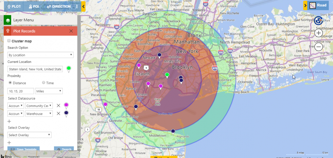
Hector decides to drop goods at all Community Centers from Warehouses so that the victims can sustain before they are rescued. After dropping the goods, survivors are picked up from the innermost and most catastrophic location to the outward and safest Community Center. Similarly, other Rescue Unit Officer and others instruct their team to follow a somewhat similar routine and conduct successful evacuation to maximum extent. As the situation is impromptu it means it cannot be estimated how many people are brought to the Community Center from affected areas via boats and steamers. Here, Concentric Proximity Search helps in an optimized manner by using which we can perform rescue operations radius wise.
Thus we have seen how using the power of maps, a laudable task of evacuation can be performed by the nonprofit.
Maplytics, a geo-analytical tool, comes to rescue in many other live situations other than this. Using our features we can breakdown complex situation into simple scenarios and deal with them in real life.
Get your free TRIAL today from our Website or Microsoft AppSource!
Happy Mapping!


