In our earlier post on Territory Management, we saw the enhancements which are now part of our last release. With this, managers will be able to create territories automatically based on the count of the records in the required region. Once the managers create the territories using territory management within Maplytics, the field sales team can plot the territories to visualize the area they are responsible for along with the respective records of the clients they need to handle.
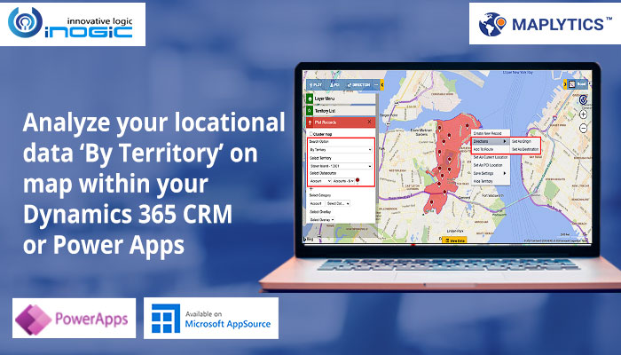
The field team can simply use the Detail map to use the option of ‘By territory’ to plot their territories. They can select the territories and the respective entity & View as Datasource and click on search. This makes it really easy to view the actual region they are responsible for and all of the clients they have been assigned to handle. They can further create an optimized route for the required clients by right clicking on the pushpins and to use the options of adding the record as a waypoint, origin or destination to a route, so as to follow while being on the field.

They can further use the ‘Open navigation links’ button in order to navigate them with turn-by-turn directions and meet the customers.

Moreover, they can create activities if they need like Appointments, Tasks or Phone Call right through the map for all the records using ‘Create Activities’ from the Mass Actions.

Once the field team starts working on their territories, their sales manager can plot all of the sales territories and see the summary card to see information on the territories. The summary card will show various information such as Territory Name, Territory Manager, and Sum & Average of Sales, Annual Revenue or any other numerical field values based on what is configured. Hence, the managers can analyse the sales for the individual territories and understand the situation of the sales team. Using this information, they can take further decisions on improving the procedures to increase sales.

This is an overview of how the search option ‘By Territory’ within the Plot Records card helps the field sales people to visualize the existing territories on the map along with the records assigned with those territories. They can also perform necessary actions on the records within to carry out their daily sales routing and hence meet their sales targets. The sales manager can further visualize the sales territories to analyze where they stand in terms of sales and then create sales strategies to be followed to improve sales.
Simplify your process of Territory creation and visualization with Territory Management within Maplytics. Download a free 15 day trial from our website or from Microsoft AppSource. To get a free demo of Maplytics features and fulfill your mapping requirements, you can also contact us at crm@inogic.com.
Until next time – keep reading and manage your territories smartly using Maplytics within Dynamics 365 CRM / PowerApps!


